The best history documentaries. Traveling from the Middle ages to the industrial revolutions, to understand the past that shaped today's world.
A glimpse into the great ancient Western and Eastern civilizations, America's
history before and after Columbus, Indian and Chinese kingdoms and empires.
As the North American colonies of France and Britain expanded, they soon
became conflicted over the strategic Ohio River Valley. The small
battles that followed would grow into a world war that would last 9
years, kill thousands, consume nations and change history forever.
This
movie was part of an English class project we had to do about the
context of a novel, and I read the book "Last of the Mohicans" by James
Fenimore Cooper.
Map showing the 1750 possessions of Britain (pink), France (blue), and Spain (green) in contemporary Canada and the United State
History Documentary: The American Revolutionary War (1775–1783) How Britain Lost The American Colonies (Full Documentary). The Historian Channel's American Independece War, Documentary.
This iconic 1846 lithograph by Nathaniel Currier
was entitled "The Destruction of Tea at Boston Harbor"; the phrase
"Boston Tea Party" had not yet become standard. Contrary to Currier's
depiction, few of the men dumping the tea were actually disguised as
Indians
The American Revolutionary War
(1775–1783), also known as the American War of Independence and the
Revolutionary War in the United States, was the armed conflict between Great
Britain and thirteen of its North American colonies, which had declared
themselves the independent United States of America. Early fighting took place
primarily on the North American continent. France, eager for revenge after its
defeat in the Seven Years' War, signed an alliance with the new nation in 1778
that proved decisive in the ultimate victory. The conflict gradually expanded
into a world war with Britain combating France, Spain, and the Netherlands.
Fighting also broke out in India between the British East India Company and the
French allied Kingdom of Mysore.
The American Revolutionary War had
its origins in the resistance of many Americans to taxes, which they claimed
were unconstitutional, imposed by the British parliament. Patriot protests
escalated into boycotts, and on December 16, 1773, the destruction of a
shipment of tea at the Boston Tea Party. The British government retaliated by
closing the port of Boston and taking away self-government. The Patriots
responded by setting up a shadow government that took control of the province
outside of Boston. Twelve other colonies supported Massachusetts, formed a
Continental Congress to coordinate their resistance, and set up committees and
conventions that effectively seized power. In April 1775 the battles of
Lexington and Concord, in Middlesex County, near Boston, began open armed
conflict between the Kingdom of Great Britain and thirteen of its colonies. The
Continental Congress appointed General George Washington to take charge of
militia units besieging British forces in Boston, forcing them to evacuate the
city in March 1776. Congress supervised the war, giving Washington command of
the new Continental Army; he also coordinated state militia units.
On July 2, 1776, the Continental
Congress formally voted for independence, and issued its Declaration on July 4.
However, it was not until August 2, 1776 that the Declaration of independence
was taken into place and first signed by Delaware. Meanwhile, the British were
mustering forces to suppress the revolt. Sir William Howe outmaneuvered and
defeated Washington, capturing New York City and New Jersey. Washington was
able to capture a Hessian detachment at Trenton and drive the British out of
most of New Jersey. In 1777 Howe's army launched a campaign against the
national capital at Philadelphia, failing to aid Burgoyne's separate invasion
force from Canada. Burgoyne's army was trapped, and surrendered after the
Battles of Saratoga in October 1777.
This American victory encouraged
France to enter the war in 1778. Spain joined the war in 1779, as an ally of
France under the Pacte de Famille.
In 1778, having failed in the
northern states, the British shifted strategy toward the south, bringing
Georgia and South Carolina under control in 1779 and 1780. However, the
resulting surge of Loyalist support was far weaker than expected. In 1781,
British forces moved through Virginia and settled at Yorktown, but their escape
was blocked by a French naval victory in September. Led by Count Rochambeau and
Washington, a combined Franco-American army launched a siege at Yorktown and
captured more than 8,000 British troops in October.
The defeat at Yorktown finally
turned the British Parliament against the war, and in early 1782 they voted to
end offensive operations in North America. The war against France and Spain
continued, with the British defeating the Great Siege of Gibraltar, and
inflicting several defeats on the French in 1782. In 1783, the Treaty of Paris
ended the war and recognized the sovereignty of the United States over the
territory bounded roughly by what is now Canada to the north, Florida to the
south, and the Mississippi River to the west. France gained its revenge and
little else except a heavy national debt, while Spain acquired Great Britain's
Florida colonies.
THE ALAMO: THE REAL STORY (WILD WEST HISTORY DOCUMENTARY)
The Battle of the Alamo (February 23 – March 6, 1836) was a
pivotal event in the Texas Revolution. Following a 13-day siege, Mexican troops
under President General Antonio López de Santa Anna launched an assault on the
Alamo Mission near San Antonio de Béxar (modern-day San Antonio, Texas, United
States), killing all of the Texian defenders. Santa Anna's cruelty during the
battle inspired many Texians—both Texas settlers and adventurers from the
United States—to join the Texian Army. Buoyed by a desire for revenge, the
Texians defeated the Mexican Army at the Battle of San Jacinto, on April 21,
1836, ending the revolution.
This is a drawing of the
Alamo Mission in San Antonio. It was first printed in 1854 in Gleason's
Pictorial Drawing Room Companion
Several months previously, Texians had driven all Mexican
troops out of Mexican Texas. About 100 Texians were then garrisoned at the
Alamo. The Texian force grew slightly with the arrival of reinforcements led by
eventual Alamo co-commanders James Bowie and William B. Travis. On February 23,
approximately 1,500 Mexicans marched into San Antonio de Béxar as the first
step in a campaign to retake Texas. For the next 10 days the two armies engaged
in several skirmishes with minimal casualties. Aware that his garrison could
not withstand an attack by such a large force, Travis wrote multiple letters
pleading for more men and supplies, but fewer than 100 reinforcements arrived
there.
In the early morning hours of March 6, the Mexican Army
advanced on the Alamo. After repulsing two attacks, the Texians were unable to
fend off a third attack. As Mexican soldiers scaled the walls, most of the
Texian soldiers withdrew into interior buildings. Defenders unable to reach
these points were slain by the Mexican cavalry as they attempted to escape.
Between five and seven Texians may have surrendered; if so, they were quickly
executed. Most eyewitness accounts reported between 182 and 257 Texians died,
while most historians of the Alamo agree that around 600 Mexicans were killed
or wounded. Several noncombatants were sent to Gonzales to spread word of the
Texian defeat. The news sparked both a strong rush to join the Texian army and
a panic, known as "The Runaway Scrape", in which the Texian army,
most settlers, and the new Republic of Texas government fled from the advancing
Mexican Army.
Within Mexico, the battle has often been overshadowed by
events from the Mexican–American War of 1846–48. In 19th-century Texas, the
Alamo complex gradually became known as a battle site rather than a former
mission. The Texas Legislature purchased the land and buildings in the early
part of the 20th century and designated the Alamo chapel as an official Texas State
Shrine. The Alamo is now "the most popular tourist site in Texas".The
Alamo has been the subject of numerous non-fiction works beginning in 1843.
Most Americans, however, are more familiar with the myths spread by many of the
movie and television adaptations, including the 1950s Disney miniseries Davy
Crockett and John Wayne's 1960 film The Alamo.
The Mexican–American War, also known as the Mexican War, the
U.S.–Mexican War or the Invasion of Mexico, was an armed conflict between the
United States of America and the United Mexican States from 1846 to 1848. It
followed in the wake of the 1845 US annexation of Texas, which Mexico
considered part of its territory, despite the 1836 Texas Revolution.
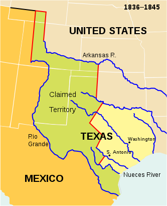
The Republic of Texas. The present-day outlines of the individual US states are superimposed on the boundaries of 1836–1845.
After its independence in 1821 and brief experiment with
monarchy, Mexico became a republic in 1824, characterized by considerable
instability, so that when war broke out in 1846, Mexico was ill-prepared for
this conflict. The war with the United States followed in the wake of
decades of Indian raids in the sparsely settled north of Mexico, which the
avenger government-sponsored American migration to the Mexican province of
Texas was aimed at buffering. Americans and some Mexicans revolted against the
Mexican government in the 1836 Texas Revolution, creating a republic not
recognized by Mexico, which still claimed it as its national territory. The
1845 expansion of US territory with its annexation of Texas escalated the
dispute between the United States and Mexico to open war.
In 1844 James K. Polk, the newly-elected president, made a
proposition to the Mexican government to purchase the disputed lands. When that
offer was rejected, troops from the United States were moved into the disputed
territory of Coahuila. These troops were then attacked by Mexican troops,
killing 12 American troops and taking 52 prisoners. These same Mexican troops
later laid siege to a US fort along the Rio Grande. This would lead to the
conflict that resulted in the loss of much of Mexico's northern territory.
US forces quickly occupied Santa Fe de Nuevo México and Alta
California Territory, then invaded parts of Northeastern Mexico and Northwest
Mexico; meanwhile, the Pacific Squadron conducted a blockade, and took control
of several garrisons on the Pacific coast farther south in Baja California
Territory. Another American army, under the command of General Winfield Scott,
captured the capital Mexico City, marching from the port of Veracruz, virtually
unopposed.
The 1848 Treaty of Guadalupe Hidalgo ended and specified the
major consequence of the war: the Mexican Cession of the territories of Alta
California and Santa Fe de Nuevo México to the United States in exchange for
$15 million. In addition, the United States assumed $3.25 million of debt owed
by the Mexican government to US citizens. Mexico recognized the loss of Texas
and thereafter cited the Rio Grande as its national border with the United
States.
American territorial expansion to the Pacific coast had been
the goal of US President James K. Polk, the leader of the Democratic Party.
The war was highly controversial in the United States, with the Whig Party,
anti-imperialists and anti-slavery elements strongly opposed. Critics in the
United States pointed to heavy casualties of the US forces and high monetary cost
of the conflict. The war intensified the slavery issue in the United States,
leading to bitter debates that culminated in the bloody American Civil War.
In Mexico, the war came in the middle of
political turmoil, which increased into chaos during the conflict. The military
defeat and loss of territory was a disastrous blow, causing Mexico to enter
"a period of self-examination ... as its leaders sought to identify and
address the reasons that had led to such a debacle." In the immediate aftermath
of the war, some prominent Mexicans wrote that the war that resulted in
"the state of degradation and ruin" in Mexico, and saw for "the
true origin of the war, it is sufficient to say that the insatiable ambition of
the United States, favored by our weakness, caused it." The shift in
the Mexico-U.S. border left many Mexican citizens separated from their national
government. For the indigenous peoples who had never accepted Mexican rule, the
change in border meant conflicts with a new outside power.
History Documentary: The New World, Colonial history of the United States of America; American History, Full Documentary, Historian Channel.
Colonial Williamsburg, View of the reconstructed Raleigh Tavern
on Duke of Gloucester Street
This documentary traces the discovery of America and early voyages by
European explorers. It shows Indian civilizations encountered by the
Spanish, Spanish colonization, English freebooters on the Spanish Main,
and the life of early settlers in New England and the South.
The
colonial history of the United States covers the history of European
settlements from the start of colonization of America until their
incorporation into the United States. In the late 16th century, England,
France, Spain and the Netherlands launched major colonization programs
in eastern North America. Small early attempts often disappeared;
everywhere the death rate of the first arrivals was very high.
Nevertheless successful colonies were established. European settlers
came from a variety of social and religious groups. No aristocrats
settled permanently, but a number of adventurers, soldiers, farmers, and
tradesmen arrived. Diversity was an American characteristic as the
Dutch of New Netherland, the Swedes and Finns of New Sweden, the English
Quakers of Pennsylvania, the English Puritans of New England, the
English settlers of Jamestown, and the "worthy poor" of Georgia, came to
the new continent and built colonies with distinctive social,
religious, political and economic styles. Non-British colonies were
taken over and the inhabitants were all assimilated, unlike in Nova
Scotia, where the British expelled the French Acadian inhabitants. There
were no major civil wars among the 13 colonies, and the two chief armed
rebellions (in Virginia in 1676 and in New York in 1689–91) were
short-lived failures. Wars between the French and the British—the French
and Indian Wars and Father Rale's War—were recurrent, and involved
French support for Wabanaki Confederacy attacks on the frontiers. By
1760 France was defeated and the British seized its colonies.
On
the eastern seaboard of what would become the United States, the four
distinct British regions were: New England, the Middle Colonies, the
Chesapeake Bay Colonies (Upper South) and the Lower South. By the time
European settlers arrived around 1600–1650, the majority of the Native
Americans living in the eastern United States had been ravaged by new
diseases, introduced to them decades before by explorers and sailors.
Colonizers
came from European kingdoms with highly developed military, naval,
governmental and entrepreneurial capabilities. The Spanish and
Portuguese centuries-old experience of conquest and colonization during
the Reconquista, coupled with new oceanic ship navigation skills,
provided the tools, ability, and desire to colonize the New World.
England, France and the Netherlands started colonies in both the West
Indies and North America. They had the ability to build ocean-worthy
ships, but did not have as strong a history of colonization in foreign
lands as did Portugal and Spain. However, English entrepreneurs gave
their colonies a base of merchant-based investment that needed much less
government support.
English colonies:
England made its first
successful efforts at the start of the 17th century for several reasons.
During this era, English proto-nationalism and national assertiveness
blossomed under the threat of Spanish invasion, assisted by a degree of
Protestant militarism and the energy of Queen Elizabeth. At this time,
however, there was no official attempt by the English government to
create a colonial empire. Rather, the motivation behind the founding of
colonies was piecemeal and variable. Practical considerations, such as
commercial enterprise, overpopulation and the desire for freedom of
religion, played their parts. The main waves of settlement came in the
17th century. After 1700 most immigrants to Colonial America arrived as
indentured servants—young unmarried men and women seeking a new life in a
much richer environment. Between the late 1610s and the American
Revolution, the British shipped an estimated 50,000 convicts to its
American colonies. The first convicts to arrive pre-dated the arrival of
the Mayflower.
New England:
New England is the oldest clearly
defined region of the United States. While New England was originally
inhabited by Indigenous peoples, English Pilgrims and especially
Puritans, fleeing religious persecution in England, arrived in the
1620-1660 era. They dominated the region; their religion was later
called Congregationalism. They and their descendants are called Yankees.
Farming, fishing and lumbering prospered, as did seafaring and
merchandising.
Geronimo (Mescalero-Chiricahua: Goyaałé [kòjàːɬɛ́] "the
one who yawns"; June 16, 1829 – February 17, 1909) was a prominent leader
from the Bedonkohe band of the Chiricahua Apache tribe. From 1850 to 1886
Geronimo joined with members of three other Chiricahua Apache bands—the
Chihenne, the Chokonen and the Nednhi—to carry out numerous raids and commit
widespread depredations in the northern Mexico states of Chihuahua and Sonora,
and in the southwestern American territories of New Mexico and Arizona. Geronimo's
raids and related combat actions were a part of the prolonged period of the
Apache-American conflict, that started with American settlement in Apache lands
following the end of the war with Mexico in 1848. The Apache-American conflict
was itself a direct outgrowth of the much older Apache-Mexican conflict which
had been ongoing in the same general area since the beginning of
Mexican/Spanish settlement in the 1600's.
George Armstrong Custer (December 5, 1839 – June 25, 1876)
was a United States Army officer and cavalry commander in the American Civil
War and the American Indian Wars. Raised in Michigan and Ohio, Custer was
admitted to West Point in 1857, where he graduated last in his class in 1861.
With the outbreak of the Civil War, Custer was called to serve with the Union
Army.
Brevet Major General George Armstrong Custer in field uniform, 1865.
Born
December 5, 1839
New Rumley, Ohio
Died
June 25, 1876 (aged 36)
Little Bighorn, Montana
Place of burial
initially on the battlefield;
later reinterred in West Point Cemetery
Years of service
1861–1876
Rank
Lieutenant Colonel
Custer developed a strong reputation during the Civil War.
He participated in the first major engagement, the First Battle of Bull Run on
July 21, 1861 near Washington, D.C. His association with several important
officers helped his career, as did his success as a highly effective cavalry
commander. During the war, Custer was eventually promoted to captain of the
U.S. Army (May 1864), and to the temporary ranks of (brevet) major general of
the U.S. Army (March 1865) and major general of the U.S. Volunteers (April
1865) at age 25. At the conclusion of the Appomattox Campaign, in which he and
his troops played a decisive role, Custer was present at General Robert E.
Lee's surrender to General Ulysses S. Grant on April 9, 1865.
After the Civil War, Custer remained a major general in the
U.S. Volunteers until they were mustered out by February 1866. He reverted to
his permanent rank of captain and was appointed a lieutenant colonel in the
U.S. 7th Cavalry Regiment, in July 1866. He was dispatched to the west in 1867
to fight in the American Indian Wars. On June 25, 1876, while leading the 7th
at the Battle of the Little Bighorn in Montana against a coalition of Native
American tribes, he and all of his battalion were killed including two of his
brothers. The battle is popularly known in American history as "Custer's
Last Stand." Custer and his regiment were defeated so decisively at the Little
Bighorn that it has overshadowed all of his prior achievements.
The Viking Deception - History Documentary; Vinland Map, NOVA's program, Vikings Discovery of America, Full Documentary: Viking and the Americas
ea-faring Danes depicted invading England. Illuminated illustration from the 12th century Miscellany on the Life of St. Edmund. Pierpont Morgan Library.
Ever since its sensational unveiling by Yale University scholars in
October 1965, the Vinland Map has been a lightning rod for passionate
debate. Most reviews of the arguments, including NOVA's program, have
focused on scientific tests designed to gauge the authenticity of the
map's ink. The opinions of experts in cartography and historical
manuscripts have commanded much less attention, yet from the outset
scholars in these disciplines pointed out glaring anomalies in the case
for the Vinland Map's authenticity. (To inspect the map, see The Map in
Question.)
Most striking of all, the coasts of Greenland and
Iceland are suspiciously close to their outlines in a modern atlas. Yet
none of the Icelandic sagas identifies Greenland as an island, and
archeological discoveries indicate that Viking colonists, hunters, and
traders explored Greenland's west coast perhaps as far north as Thule
and Cape York, but no farther. Even a century or two after the supposed
date of the Vinland Map, European mapmakers were still divided about how
to draw Greenland—as an island, part of an arctic landmass, or a
peninsula dangling down from northern Europe. The precision of the
outlines of Greenland and Iceland is all the more surprising when
compared to the Vinland Map's depiction of the Viking homelands in
Scandinavia, which are barely recognizable: Sweden has migrated to the
wrong side of the Baltic while Norway has been flipped to match the
map's overall egg-shaped design.
Did the Vikings make maps?
Could
the accuracy of the Vinland Map be testimony to the Vikings'
extraordinary seamanship and mapmaking skills? Did the alleged medieval
author of the map use an earlier Viking map as a source of information?
Unquestionably, the Vikings were the most audacious and accomplished
voyagers of the medieval world. Their sleek, clinker-built longships and
bulkier cargo boats had reached Iceland during the 9th century A.D. and
Greenland during the 10th, leading to permanent colonies and regular
trade with the Scandinavian homelands. Beginning in 1961, the excavation
of longhouses and typical Norse artifacts at L'Anse aux Meadows in
Newfoundland proved that Greenland settlers had reached North America,
ju
Such far-flung voyages of discovery demanded special
navigation skills. An Icelandic codex known as Hauksbok details signs
such as the appearance of whales, seabirds, and distant mountain peaks
that voyagers would watch for as they crossed the open ocean. Viking
sailors may also have developed simple astronomical aids, such as
steering by the sun or the Pole Star, although there is no firm evidence
for these practices. But however accomplished their seamanship, the
Vikings never seem to have charted the coastlines they explored. Despite
the detailed navigational texts and abundant geographical references in
the sagas, no Norse cartographic drawing or engraving has survived.
They don't appear to have been mapmakers at all.
The colorful
Icelandic tales of Leif Eriksson and his followers did inspire European
mapmakers to create North American charts identifying features mentioned
in the stories, such as Markland, Helluland, and Vinland. But this
interest in the sagas only took off during the 16th and 17th
centuries—long after the purported mid-15th-century date of the Vinland
Map. Beginning around 1570, Protestant mapmakers began incorporating new
knowledge of the Americas based on pioneering Portuguese and English
voyages of discovery. A strong motive for documenting the earlier Norse
traditions of settlement was to repudiate Catholic maps and territorial
claims defined by papal treaties. But even the most detailed of these
maps, such as the Resen Map of 1605, appears to have been mainly an
exercise in fantasy.
Credits:
The Forger's Inspiration by Evan Hadingham http://www.pbs.org/wgbh/nova/vinland/inspiration.html
500 Nations The Story of Indian Americans Part 1. Hosted by Kevin Kostner.
Ancient Pueblo peoples or Ancestral Pueblo peoples were an ancient Native American culture centered on the present-day Four Corners area of the United States, comprising southern Utah, northeastern Arizona, northern New Mexico, and southwestern Colorado. They lived in a range of structures, including pit houses, pueblos, and cliff dwellings designed so that they could lift entry ladders during enemy attacks, which provided security. Archaeologists sometimes refer to the unique set of material culture remains as "Anasazi".
Monks Mound, built c. 950-1100 CE and located at the Cahokia Mounds UNESCO World Heritage Site near Collinsville, Illinois, is the largest Pre-Columbian earthwork in America north of Mesoamerica.
The varying cultures collectively called Mound
Builders were inhabitants of North America who, during a 5,000-year period,
constructed various styles of earthen mounds for religious and ceremonial,
burial, and elite residential purposes. These included the Pre-Columbian
cultures of the Archaic period; Woodland period (Adena and Hopewell cultures);
and Mississippian period; dating from roughly 3400 BCE to the 16th century CE,
and living in regions of the Great Lakes, the Ohio River valley, and the
Mississippi River valley and its tributary waters. Beginning with the
construction of Watson Brake about 3400 BCE in present-day Louisiana, nomadic
indigenous peoples started building earthwork mounds in North America nearly
1,000 years before the pyramids were constructed in Egypt.
Since the 19th century, the prevailing
scholarly consensus has been that the mounds were constructed by indigenous
peoples of the Americas. Sixteenth-century Spanish explorers made contact with
natives living in a number of later Mississippian cities, described their
cultures, and left artifacts.[2] By the time of United States westward
expansion two hundred years later, Native Americans were generally not
knowledgeable about the civilizations that produced the mounds. Research and
study of these cultures and peoples has been based mostly on archaeology and
anthropology.




.jpg)


